


Aliceville 5 National Guard, Pickens County, Alabama
About
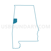
Outline

Summary
| Unique Area Identifier | 522791 |
| Name | Aliceville 5 National Guard |
| County | Pickens County |
| State | Alabama |
| Area (square miles) | 10.25 |
| Land Area (square miles) | 10.23 |
| Water Area (square miles) | 0.02 |
| % of Land Area | 99.77 |
| % of Water Area | 0.23 |
| Latitude of the Internal Point | 33.05677690 |
| Longtitude of the Internal Point | -88.06787990 |
Maps


Graphs
Select a template below for downloading or customizing gragh for Aliceville 5 National Guard, Pickens County, Alabama


Neighbors
Neighoring Voting District (by Name) Neighboring Voting District on the Map
- Aliceville 2 Nat'l Guard Armory, Pickens County, AL
- Benevola Community Center, Pickens County, AL
- Lewiston Comm. Center, Greene County, AL
- West Greene Fire Dept., Greene County, AL